
HISTORIC PRINTS
16" x 24" 1844 Map of The Oregon Territory Columbia River Northwest Pacific
£111.93
£186.55
Save 40% (£74.62)
-
 Order within 17 hours and 10 minutes to get between May 25 - May 31
 -
 Tracked Shipping on All Orders
-
 14-Day Returns
- Secure Payments
-
 24/7 Customer Support
Description
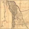
Map of the Oregon Territory. Relief shown by hachures. Mounted on cloth. Some acid offset on map. Inset: Columbia River, reduced from a survey / made by the U.S. Ex. Ex., 1841. Scale ca. 1:700,000. Includes notes.Shipping and Returns
- We offer tracked shipping on all orders. Tracking information will be shared as soon as the order is dispatched.
- Please check the delivery estimate before adding a product to the cart. This is displayed for every product on the website.
- Available shipping methods and charges will be displayed at the time of checkout, depending on your exact location.
- All customers are entitled to a return window of 14 days, starting from the date of delivery of the product(s).
- Customers are advised to read our return policy for details of the return process, eligibility, refunds as well as cancellations or exchanges.
- In case of any issues or concerns about Shipping or Returns, please contact us and we will be happy to help.
Historic Prints.
16" x 24" 1844 Map of The Oregon Territory Columbia River...
£111.93
£186.55
Save 40.0% (£74.62)